camera operator

I specialize in nature/wildlife recordings from unique angles. To tell a compelling story I prepare as much as possible to capture the DPs or my vision. If the circumstances call for it, I improvise on the fly. I love to rig cameras for special use cases, no matter the shooting conditions. Be it at land, underwater or in the sky, I always strive for the smoothest focus pulls, pans, tilits, zooms and aperture ramps.
I use prime lenses as well as zooms. I can cover a wide range of focal lengths, from ultra wide to supertele, with my private pool of lenses, which is continuously growing. Check out my gear list here!
presentations

Are you looking for an exciting presentation about adventure photography? Look no further!
I offer talks on the following topics:
-
Volcano Photography - Chance of Survival 50:50: Let me take you on a journey to three volcanoes that can´t be more different from each
other. From Indonesia, to the Canary Island and off to Sicily. Learn about the tragic stories these gigantic fire factories have to tell and enjoy a view behind the curtains of
such an expedition, as well as the things that didn´t went as planned.
Duration approx. 90 minutes (English or German)
Preview here and here!
- Maasai Mara: Take a deep dive into one of the most diverse and beautiful regions of the Serengeti. You´ll meet giant crocodiles right next to hippos along the Mara River, exotic birds, elegant giraffes and antilops. We will join a lion pride and cheetahs on their hunt in the vast landscape called the Maasai Mara!
-
Duration approx. 60 minutes (English or German)
Preview here!
Aerial
Coverage & mapping

You need detailed high resolution aerial footage? This is what I offer:
- 4K Timelapse or Hyperlapse for news, TV shows, movies, documentaries or monitoring progress of construction sites.
- Cinematic videos in 4K as MP3 or MOV (H.264/MPEG-4 AVC, H.265/MPEG-H Part 2/HEVC). Color grading and other post processing is an optional addition.
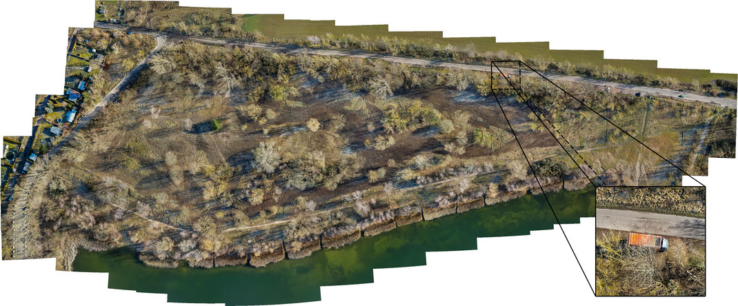
- Automated habitat mapping large areas up to an altitude of 120 m (higher altitude with special permits possible). Maps can be georefferenced for QGIS or ArcGIS. The advantage of drone mapping compared to conventional mapping from the ground, is that hard to reach places can be easily accessed and the time spend is the field is tremendously reduced. Each mapping session can be saved and repeated over and over again.
- Photos and videos of weddings, concerts, work events and many more...